|
DataMars orbital images: HiRISEThis data set contains 3820 landmarks that were extracted from 168 HiRISE images. The landmarks were detected in HiRISE browse images. For each landmark, we cropped a square bounding box the included the full extent of the landmark plus a 30-pixel margin to left, right, top, and bottom. Each cropped image was then resized to 227x227 pixels. Class labels for each image are in labels-map-proj.txt. A Python dictionary that maps class ids to semantic names is in landmarks_mp.py. Contents:
Download:
Attribution: If you use this data set in your own work, please cite this DOI: 10.5281/zenodo.1048301 . Please also cite this paper, which provides additional details about the data set: Kiri L. Wagstaff, You Lu, Alice Stanboli, Kevin Grimes, Thamme Gowda, and Jordan Padams. "Deep Mars: CNN Classification of Mars Imagery for the PDS Imaging Atlas." Proceedings of the Thirtieth Annual Conference on Innovative Applications of Artificial Intelligence, 2018. Mars surface images: MSL roverThis data set consists of 6691 images that were collected by the Mars Science Laboratory (MSL, Curosity) rover by three instruments (Mastcam Right eye, Mastcam Left eye, and MAHLI). These images are the "browse" version of each original data product, not full resolution. They are roughly 256x256 pixels each. We divided the MSL images into train, validation, and test data sets according to their sol (Martian day) of acquisition. This strategy was chosen to model how the system will be used operationally with an image archive that grows over time. The images were collected from sols 3 to 1060 (August 2012 to July 2015). The exact train/validation/test splits are given in individual files. Full-size images can be obtained from the PDS through the PDS Imaging Atlas. Contents:
Download:
Attribution: If you use this data set in your own work, please cite this DOI: 10.5281/zenodo.1049137 . Please also cite this paper, which provides additional details about the data set. Kiri L. Wagstaff, You Lu, Alice Stanboli, Kevin Grimes, Thamme Gowda, and Jordan Padams. "Deep Mars: CNN Classification of Mars Imagery for the PDS Imaging Atlas." Proceedings of the Thirtieth Annual Conference on Innovative Applications of Artificial Intelligence, 2018. |
SoftwareRockIT Image Annotator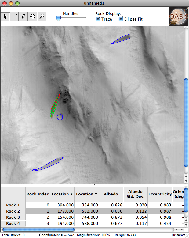
The RockIT software was developed by the OASIS project to enable manual outlining of rocks in an image. We extended this software for use with landmarks in general (and to add the ability to open multiple images at once and other capabilities). The user can click the vertices of a polygon outlining a landmark, or use a pencil tool to draw the shape freehand. RockIT also displays the extracted features for each landmark, including center location, albedo (intensity), and attributes of the ellipse fit. The ellipse fit itself is shown in green (toggled with the "ellipse fit" check box). Click the screenshot at right for a larger version. Contributors to this software include Ben Bornstein, Andres Castano, Tim Stough, and Lucas Scharenbroich. MatchGUI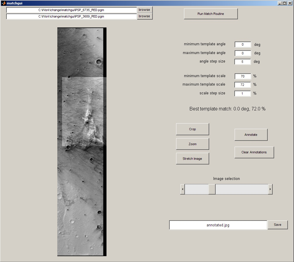
MatchGUI, implemented in MATLAB, provides easy viewing of two images of the same region. It co-registers the two images (compensating for changes in scale and rotation) and displays the registered pair as an adjustable overlay, making it easy to identify any changes. It also supports simple annotations of the resulting composite image, e.g. to mark the changed regions. Click the screenshot at right for a larger version. This software was developed by Adnan Ansar. |